

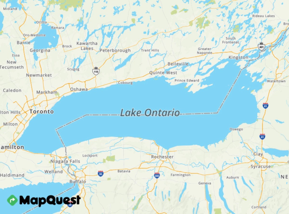
MapQuest stood up to President Donald Trump, and now its app is reaping the rewards.
The “OG of online mapping,” as the company calls itself, announced on Thursday that it would not change the name of Lake Ontario on its maps to Lake America, despite Trump’s executive order directing the U.S. Department of the Interior to update the lake’s name in the U.S. geographic naming service. As a result, MapQuest’s mobile app downloads soared, sending the iOS app to the No. 4 position on the U.S. App Store’s Top Charts for apps (not including games) as of Monday morning on the U.S. east coast.
MapQuest also reached the No. 8 position overall in the U.S. App Store across both apps and games, and it became the No. 1 Navigation app in the United States.
Great! Hope people more move away from Google Maps. OSM would be even better, but MapQuest is a good step away from the Monopoly of Google.
Edit: Just realized that in Google Maps the acronym for the Great Lakes is no longer “HOMES” but could now be known as “SHAME”.
If you’ve got a favorite replacement for the Google Maps mobile app, this would be a great place to tell people about it. I believe the world of Open Street Map (OSM) is likely to be a little intimidating, a little daunting, for the masses, so an easy starting point might be especially helpful.
Copy-pasting my own comment:
For using OSM on Android (edit: and iOS):
- I use OsmAnd, which is free on F-Droid. It’s very feature-rich, and I can customize it pretty much exactly how I like. There’s a good tutorial for beginners here.
- However, some people prefer the simplicity of the app CoMaps, which is available for Android, iOS, macOS, and Linux (Flathub). It’s a fork of Organic Maps that arose over disagreements with Organic’s governance (see: open letter).
- There are also specialty apps like Alpi Maps for more specialized uses of OSM (in Alpi Maps’ case, hiking).
For contributing to OSM on Android:
- I use Vespucci for more complex edits on Android, so things like adding features. (The rough iOS equivalent is Go Map!!.)
- I use StreetComplete for a more trimmed-down, gamified experience. It isn’t a power user experience like Vespucci, but it’s often really useful if you’re just on the go and want to make small but meaningful contributions.
The easiest way I’ve found to contribute local information is the iD editor on desktop; it’s the one that pops up if you click ‘Edit’ on OpenStreetMap.org. It strikes a good balance between user-friendliness and power user stuff. For full-on power users, JOSM is a good option. And the easiest way to contribute in a limited way is StreetComplete, which will ask you questions about existing features (like “does this traffic signal have a walk button for pedestrians?”)
The OpenStreetMap Wiki is a great general resource for using and contributing.
- I use StreetComplete for a more trimmed-down, gamified experience.
Another benefit for casual users is that StreetComplete doesn’t require you to worry about the details of formatting your submissions, it simply asks you if this thing is here, or what are the hours of this business, or if there is a sidewalk or what is the address number on this building and things like that, then it submits a correctly formatted response to the OSM database.
Note: OsmAnd is available on Android and iOS, too.
https://apps.apple.com/us/app/osmand-maps-travel-navigate/id934850257
… Huh. Can’t believe I forgot this.
Those are great choices for navigation. What options are there for map/location based business search?
I don’t think I understand the question. OsmAnd and CoMaps are both meant to show businesses, and how much information those businesses have is, for most cases, dependent upon what’s in the underlying OSM database, not what OsmAnd or CoMaps are able to show.
On OsmAnd, for example, I’m able to go to
Configure Map>POI Overlayand select whatever type of POI I’m looking for. In CoMaps (mobile), I can select the magnifying glass and then go toCategories.In CoMaps (mobile), I can select the magnifying glass and then go to
Categories.Omfg I’m a dumbass, I never noticed the categories tab in CoMaps!
Dude, I forgot OsmAnd had an iOS version until like a couple hours ago. We’re all dumbasses on this blessed day.
Use CoMaps. It’s a privacy-first app that pulls their map data from OpenStreetMaps. If something is inaccurate on the map, you can edit it on OSM and it’ll populate to most map services. I’ve made changes and seen it pop up on Google Maps too.
I downloaded CoMaps from F-Droid (https://f-droid.org/), just to avoid the Google Play Store. Slowly de-Googling my life…
I don’t know if there is an iOS version. Apple is the OG evil company, long before Google got rid of their “Don’t Be Evil” motto, so I avoid their products. Now I’m trying to get off Android stuff too, but there aren’t many alternatives right now.
EDIT: Someone else linked a website for CoMaps and it does have an iOS app. Also an Apple and Linux desktop program. No Windows though.
FYI, here are the PrivacyGuides recommendations:
Not sure why they recommend Organic Maps over CoMaps.
CoMaps is a great app for iOS and Android. Cleaner interface than OsmAnd. FOSS and uses open street maps.
Mapquest lets you have a Rainbow Unicorn icon. Sorry OSM, MapQuest wins.
But but we at OSM have interminable discussion about how to map several flavors of lgbtq stuff. Surely that must count for something?! Also here is an OSM project to show these places https://pkoby.github.io/LGBTQmap/#13/51.4979/-0.0887 And here’s a map with just the rainbow pedestrian crossing https://mapcomplete.org/rainbow_crossings
I just checked and OSM had the lake listed as Lake Ontario, so that app is good to go as well.
Tested CoMaps and Mapy but they don’t seem to have names of lakes and other bodies of water?
I was about to pivot to CoMaps but then saw this mapquest thing taking off…
One way or another, Google is out. GrapheneOS is in this week.
GrapheneOS is in this week
I really, really want to get there, just need to get with the program and find a good, late-model Pixel on the used market.
You need nothing special. Was running on a 7 until I broke it, now on 8a. Zero issues. I buy mine used on eBay. They are all the same candy bar anymore. Does .2150 extra sq inches of screen really matter?
I used to buy the top shelf phones. Went to pixel a-types and gave never felt like I am missing anything.
The 9 Pro has served me well since I got it shortly after release. 👍
OSMAnd is horrendous to use on Android if you just need to get simple directions.
It also misses a ton of roadworks in my area, so it’s quite literally unusuable. More than half the time it will try to route me along a closed road
OpenStreetMap also has it as Lake Ontario:

They also have navigation called OSMAnd.
Here in the You Knighted States of Murica, we ain’t gon use no OSAMA maps app
No that makes sense, I hear many Americans refuse to use GPS, because no one can tell them where to drive, they drive where they want and which way they want. Not according to what some sissy computer tells them.
FREEDOM! 😋But they’ll listen to chatgpt about shooting up a school.
It’s actually more interesting than this. Open Street Map has a long history of supporting multiple names for the same place. There seems to have been a bit of an edit war since the executive order was issued, but as of now we have
<tag k="name" v="Lake Ontario"/>and<tag k="official_name:en-US" v="Lake America"/>. There are also 36 other name tags, mostly listing the name of the lake in different languages. I initially assumed that all those others were added in the last couple of days as a way to sort of protest by taking the whole thing to an absurd level. But the change log actually shows that 27 of them were already in the tags long before the executive order was issued. And honestly, I like it this way better. Instead of making Trumps announcement big to the point of absurdity, OSM has made it small to the point of inconsequence. Trump said he wanted to change the name of the lake, and OSM said “sure, whatever, your name for it can be number 28 on the list of names that people have for it. And actually, while we’re on the topic, it looks like we missed a few. Lets throw on 8 more to make sure everyone is represented.”But I’d argue comaps is better
OSM is CoMaps’ data source.
I’m aware, probably could have worded that better on my end
Haven’t tried it, but it’s based on OpenStreetMap, so I guess it also calls it Lake Ontario.
Why is comaps better?Completely free and open source, simpler UI for anyone to get into imo
I thought OSMAND was Open Source too.
I never paid anything for using it.Osmand has a free and a paid version on play store and a fully foss version on fdroid
I’m using the one from F-Droid.
The UX is just easier to adjust to imo
OK, I’ll give it a try, although I generally use the 1 in my car. But maybe I like comaps better ?.
In my experience OsmAnd is way better than Comaps.
In OsmAnd I can type in a business name or an address and not only will it bring up the correct address but it will allow me to navigate. I can do neither in Comaps. Also OsmAnd has CarPlay/Android Auto support with the paid version.
Comaps has carplay as well
Yeah I mean at the end of the day it really comes down to preference
I haven’t tried comaps, so maybe it has similar features, but the OsmAnd profiles and plugins are great. Driving, hiking, biking, walking, basically any form of transportation can be used and with plugins and overlays show info pertinent to each method while excluding extraneous info.
And if you get it from fdroid or compile it yourself(?) it’s the pro version with more features for free.
Needs Android Auto support
Android Auto is a proprietary Google service, and so usually is restricted to the Google Play Store version of an app.
Ah good call! I’ll have to try that.
Has it? Just unfortunately only on the google store version 😭
Isn’t the navigation app called OsmAnd?
Yes it is, sorry my mistake.
Is OsmAnd legit? It’s not from OSM directly from what I recall
yes, good app
Thanks for sharing!
Worst product name ever.
Also, crappy app too. I appreciate that they are trying, but it has been crap for years.
Tried it again a few months ago. The spoken navigation wounded like it just huffed a can of butane. Real low, slow and fucked up sounding.
I try and contribute to osm as much as i can but its still worefully lacking in information like open/close hours, and public transit routes
I still use google maps 80% of the time, :(
TIL MapQuest is still around.
Years ago, I had one of those standalone GPS mappers that used it for its database. It always gave you the option to choose between shortest time and shortest distance. Generally, I went with the former, but this one time we were heading home and not in any special hurry, so I said let’s try shortest distance just for kicks.
Next thing you know, we’re on a hunting trail in the Adirondacks in a Geo Metro that was definitely NOT rated for it and my wife was absolutely freaking out while the kids were getting tossed around in the back. Good times.
Google maps does that as well. I was at Grand Teton and heading to my next camp site. 56 miles, 2.5 hours. That seems a bit low on speed. Checked closer, and yep it wanted me to take my van on a pretty rough logging road. I rerouted through Jackson WY.
Google Maps is notoriously bad with cycle routes. It has sent us over sand paths where you can’t cycle at all, when better routes are available. In cities, OSM also gives better routes.
I took a folding bike on a visit to Toronto and used GM in cycling mode. I guess it wasn’t too bad in the downtown area? But then I forgot to set it back to driving mode on the way home and it picked a rather whimsical route for a car. I thought it was just trying to stay off highways to avoid the notorious Toronto rush hour at first, but eventually, it wanted me drive through the woods on a “trail” that was barely discernible as such.
My experience as well. I use gmaps only for incity navigation if I need it. It will happily reroute you to some bumfuck nowhere to save a millilitre of gasoline.
People think I’m crazy for insisting that google maps sucks if you actually understand how to use a map and traffic reports, but it’s true.
I used it back in high school (2001ish) to give a friend’s mom directions to someone’s house. It could have taken a back country road with like 2 turns and be there in 6 minutes, but it instead took it to the nearest major road completely out of the way for a trip twice as long.
It was still on its infancy
To be fair, Google maps also put me on a mountain trail 10 years ago
Resistance at even the smallest level matters.
Yep, this orange motherfucker shouldn’t be able to do anything without going through court to force it to happen, and even then ignore it until someone shows up to MAKE you do it. Use his own bullshit against him.
Mapquest still exists? Encarta it!
I asked Jeeves, and he told me it still exists. To celebrate, I played some Neopets and then logged into a fun MUSH game.
Yeah right. Going to get that AOL disc that came with PCGamer and check if I’ve got mail next.
Canada should rename Lake Superior to Lake Obama, “because Obama is Superior”.
“because Obama is Superior”
I love that idea. This phrase makes it super-easy to remember the name change and what went before.
And the new mnemonic is HOME-O
Love this! They should just add Obama so it reads ‘Lake Superior Obama’
Just call it Lake Obama is Superior
The whole renaming thing is a distraction tactic at best.
I personally am a huge fan of CoMaps. It uses OSM data
Seconding CoMaps.
Completely replaced google maps for me a while back. It works as in-car navigation (with GPS audio queues for when noone else is doing nav), downloading maps is a highlighted feature instead of being burried in menus and it does not live sync to traffic or ask for route changes. It simply does its job and does not ask for your attention after it gets going.
I kind of like the live traffic. I want an open source ‘Waze’. Sadly there isn’t one. Magic earth came close but then they enshittified.
Ok but what if Mitch McConnell became an obsessive OSM contributor months ago and that’s why we have no news?
There’s enough of a non American user base to counter it.
I’ve been using OsmAnd. I tried CoMaps and I found it really clunky. I set it up to try on a drive home from work since I know the route. I put my address in and it brings me to the street somewhere in the city, but not to my address?
Fair enough. Open source software is something that continually improves as it gets into the hands of more people and they all voice their concerns. That’s the whole point. It’s software for people and not corporations.
I was sadly surprised to find out that Kagi maps follwed Trumps lead on misnaming both the Gulf of Mexico and Lake Ontario.
I’m likely to ditch them over this. It’s not just a matter of principal. If I can’t trust them to stand up to Trumps temper tantrums on this, how can I trust that any of their other results haven’t been tampered with?
Still says Lake Ontario for me when checking from Switzerland.
that is probably playing both sides as much as possible like google does (Lake America if you enter it from US, Ontario otherwise)
Both Lake Ontario and Gulf Of Mexico for me and I’m in the USA.
They pull from MapBox. Also I see lake Ontario on a US IP
It’s interesting that users on the Kagi forums report different answers. It seems that both US and Canadian customers may see either Lake Ontario or Lake America.
That would suggest that pulling from MapBox is orthogonal to the decision of what to show the end user.
If it makes you feel better a lot of Canadian and other international services now display it as America because they are cheap and are just all pulling it from the same Google API source.
I wish it did but that doesn’t really help me.
I’d rather a few services are good rather than that every service sinks to lowest level.
Kagi has always given me bad vibes. So I’m not really that surprised over this.
Since america now calls it Lake america we can nickname it Lac inférieure.
USA is not a Democracy when one man (President) can decide how something will be named. It seems that President have unlimited power, he can do whatever he want, manipulate markets in a most corruptive way, incarcerate who ever he want, bomb and kill at his will.
My last hope for this to be not true will be tested in November, depending on the result, I’ll finally declare USA as Fascism. But even if not, the next presidential election needs to be an entire (progressive/socialistic) turnaround, to stop this continuous degeneration of “democracy”, and there’s a lot of damage of this administration, that needs repair over the next decades.
The US is fascist.
I’m convinced that the most optimal way forward is for it to split. Why the fuck do California or New York have to keep financing a bunch of fascist mouthbreathers with genocidal tendencies? I don’t think it’s possible for the country to recover as one, whole swaths of it literally need cult deprogramming.
As I said, it certainly does have a lot of fascist tendencies, but I wouldn’t declare it fascist (yet) as long as elections are still somewhat proper, that’s why i said November is an interesting date. I think for this to be actual fascism (also do not devalue the actual fascisms we have/had so far), democracy needs to be almost entirely oppressed. We’ve seen in New York that there’s still at least a little bit of hope, for this to be turned around.
But I agree, it needs a lot of cult deprogramming, and I’m very much concerned about the mental health of the average american…
I would definitely say we have a fascist government. I do not think we have a dictatorship yet, but I do think that’s the goal of the current right wing.
… which in my understanding is a requirement for fascism.
What do you make of all their attempts to restrict voting for the upcoming election, including having lists of “eligible” (read: Republican) voters? It’s not just one or two bills either, they’re pushing this with all of their energy, including petitioning SCROTUS for emergency measures.
Is this not enough to call it fascist? Why do they need to have success before you call something for what it is? Someone with homicidal tendencies is a threat before they kill someone, why do pedophile fascists get a pass?
attempts
right, it’s obvious that they want to be fascists, and so far they are succeeding…
That’s not what I meant though. I meant that the whole system is not yet in a state that I would call fascism yet, or well, at least until this next election which I think is a very good test for the “democracy” there…
And my hope is, that Trump is that unpopular that they will indeed fail to continue with this…
Unlike smarter authoritarians/dictators, he’s not very good so far at this (although ~1/3 of the population is already brain dead, which is in his favor, but probably not enough…). But I don’t know, americans have already disappointed me twice, so it stays hope…
I’m convinced that the most optimal way forward is for it to split.
You and what army are gonna accomplish that lol?
so the army is probably still in power of trump but let’s say the midterms are very obvious in favor for the democrats. i doubt that the army is very much interested in supporting this fascism further, Trump has already disgraced himself in front of all the leaders in the army, they’re not very keen of Trump.
That is a much different statement than the one above implying that states could potentially secede. Even with the lows we’ve sunk to, secession has basically no popular will behind it and guarantees bloodshed.
I think that a (for Trump) failed midterms might avoid bloodshed, in case of secession, although that itself gets more unlikely then. But since a lot of powerful supporters of Trump are in California I also think it’s fairly unlikely anyway …
Obama renamed Denali and this guy’s been crying to prove anything Obama can change, he can change faster
Alaskans already asked for that like 50 years before though.
And tape kids
Organic maps still has the gulf of Mexico not the gulf of trumps taint.
I’ve been happy with Organic Maps
Isn’t it over now? Did you mean CoMaps?
I don’t think he knows about CoMaps pip.
Organic Maps is still a thing. I see that they had an update a week ago on the app store. CoMaps was a fork of OM and some (most?) of the devs left, but OM didn’t stop being developed.
Interesting… I assumed it was dead Anyways CoMaps ftw!
Yeah, CoMaps definitely captured most of the attention when it forked and explained why, but I guess the Organic Maps devs who remained kept at it.
MapQuest needs to add Android Auto support. Loving the icons, though!
Second that
I desperately need to get off Google Maps, especially now that it shows Lake America for me up in Canada.
Unfortunately MapQuest has virtually no support for biking/transit/walking, driving is the only option. It also lacks support for collaborative lists, which my partner and I use extensively. I’m still trying to find a viable alternative, happy to take recommendations if they have these features.
I use Organic Maps as my standard maps app which is an Open Street Map based app. I find it’s pretty good but can be a bit lost around heavy traffic. Cycling is definitely an option. I’ve not seen “collaborative lists” in the software but I’ll take a look. I sometimes use the google maps web service because for some reason Open Street Maps doesn’t display suburb when searching for a location and it can be really confusing to figure our which one you are looking for.
How is the Quality of Openstreetmap Based Maps and Apps for you? For Example Mapy, Comaps or Osmand.
The last time I used an OSM based map was yeaaaaaaaars ago so I can’t say, but I also can’t imagine shared lists are well supported in that ecosystem? I might be wrong of course (but everyone knows stating a wrong thing on the Internet is how you get real answers)
The other issue I’ve been running into is that Maps is unfortunately still the best way to get business data since anything else requires businesses to add their info to it. On Maps I can find store hours, menus, phone numbers, reviews, etc.
The other issue I’ve been running into is that Maps is unfortunately still the best way to get business data since anything else requires businesses to add their info to it. On Maps I can find store hours, menus, phone numbers, reviews, etc.
Well the easiest way is to add it by yourself. There are Apps which are build for that. For Example Streetcomplete or Mapcomplete. All you need is an Openstreetmap Account and you are good to go.
Take a look at this Supermarket in Germany: In OSM - In Mapy
You can add a lot of details but not every App shows them. Mapy also has your review system you wanted. So all you need is Family and Friends (and Lemmy Users) to join and rate every store in their Town.
If you want I could take a look in some towns and see if the data that is collected is good or not. Europe has a good OSM Coverage, America not so much it’s more like the basics. Canada I don’t know.
Street complete is such a great app. Highly recommended.
Use it instead of a game to waste time it’s that easy to use.
Here WeGo

Just checked Waze, and they are still showing Lake Ontario.
Waze? Ew.
You know that’s Israeli tech that shares data with Palantir right?
You know it’s owned by Google so it’s really weird that it’s still showing that
Honestly I didn’t. I just knew they shared data with Palantir and when I went to confirm that I also found out that it was an Israeli app.
Is Google supposed to be better?
Luckily I tried the app once and deleted it instantly because it was burning through battery at a ridiculous rate.
They bought it years ago. Most of the features are integrated into Google maps. It is better then Israeli owned. But it’s still not great. But it makes it weird that they haven’t changed the name on that.
Thank you
Waze is Google. The change is coming.